Watershed modeling utilizing Hydrologic Engineering Center – River Analysis System (HEC-RAS) software has come a long way over the past four years.
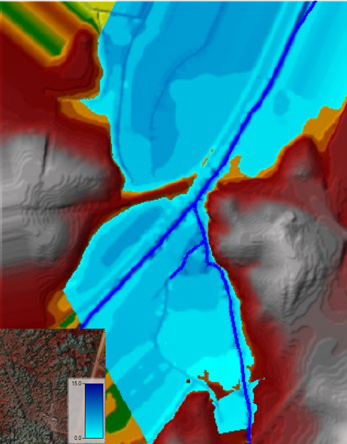
Sample Creek 100-year flood boundary with water depth
The most recent version – Version 5.0.6 – was released in November 2018. HEC-RAS version 5.0.6 has maintained the capability of modeling one-dimensional, steady and unsteady flow that users of past versions are familiar with, however, this newest version also includes two-dimensional hydraulic connections, storage areas, structures, variable time step capabilities, and modeling hydraulic effects of cross section shape changes, bends and other 2D aspects of flow which is very exciting.
A decade ago, when civil engineers and GIS analysts would delineate floodplain boundaries for Federal Emergency Management Agency (FEMA) Flood Insurance Rate Maps (FIRMs), the process was sometimes tedious and it was necessary to utilize Microsoft Excel macros to help aid the transition from shifting survey data in ArcMap to identifiable cross-sections HEC-RAS software. With the HEC-RAS Version 5.0 to Version 5.0.3 releases, many software wish list items were met and further enhancements and/or bug fixes then led to subsequent versions. Developing a digital elevation model (DEM) from survey data within a project area and creating a terrain directly in the RAS Mapper user interface is time-saving. From this interface, an engineer can plot contour lines intervals down to one-tenth and efficiently extract 1D rivers, bank lines, flow lines, and cross-sections that represent present conditions; extract 2D model elements; and begin entering model parameters from the geometry developed in RAS Mapper. Following a successful model run, the user can quickly view the model output in this interface without transitioning the output to other software. This ability is truly beneficial to those functioning without an ArcGIS license or with a limited number of licenses.
As the public is becoming increasingly aware of floodways and is positively engaged in protecting our country’s water bodies, this software’s enhancements help stormwater engineers be more responsive in earlier project design stages and also facilitate communication of hydraulic results with visual maps that complement technical text.
~ Tara Mallison is a professional engineer with an M.S. in Civil & Environmental Engineering supporting LDA Engineering’s dedicated team. She has accomplished watershed-based protection plans, stormwater designs, low impact development, water distribution models, and sanitary sewer rehabilitation and extension projects. Tara has a passion for learning something new each day and strives for a biodiverse world.